Click to
enlarge
 |
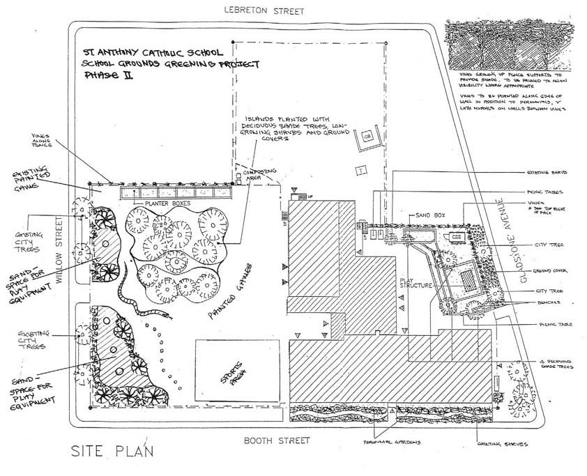
1. Sample
base plan
This example of a base site plan shows the property boundaries and buildings. Some plans include the location of trees, play equipment, benches, driveways, garbage receptacles and water catchment basins and indicate surface materials such as grass, asphalt, gravel, etc. The location of infrastructure such as hydro, gas and water may also be shown. There is usually a key on the plan that uses letters (such as CB for catchment basin, HP for hydro pole or CSS for concrete storage shed), that will help you identify different components on the site.
2. Sample Overlays
Acetate overlays are a useful way of building your site plan. You can record different kinds of information on each of several overlays. You can look at the details on each overlay separately and also place combinations of overlays on top of each other to see how the various components of the site and the activities that take place on the grounds are likely to affect one another. In addition to the following examples, you might also consider creating overlays showing, for example, the results of the shade and biodiversity surveys.
Click to
enlarge
 |
a. Site
conditions
An overlay showing the different conditions on the site such as wind direction, shade, wet areas, edges and corners where litter collects, cracked paving, etc., is useful because it helps people remember when planning the areas requiring improvement or repairs. It is also helpful to show places where conflict arises due to two or more incompatible uses being in close proximity to one another. Planting constraints such as snow storage areas, fire lanes and the location of underground cables and pipes can also be identified on this overlay.
Click to
enlarge
 |
b. People
and vehicle routes
This overlay marks the routes used by people and vehicles. It helps you to determine where projects can be located and to avoid placing projects across "desire lines" or where people and vehicles traverse the site to reach different destinations.
Click to
enlarge
 |
c.
Comments about the school yard
Making an overlay with some of most frequently-mentioned site problems or preferred areas on the grounds will help you remember the problems that need solving and the spaces that should be preserved when developing the final plan.
Click to
enlarge
 |
d.
Greening plan
This overlay shows how, by going through the process of eliminating the areas of the grounds that cannot be transformed due to site constraints and the routes used by people and vehicles, you can identify the spaces in between that can be greened.
[ Back to top ]
|
)
)
)
)